On 16–17 June 2022 our team took part in the multidisciplinary field campaign “SFR Campus de la Mer” at Baie de Wissant on the English Channel coast. The site organiser and host was the French laboratory LPCA (Laboratoire de Physico-Chimie de l’Atmosphère) at the Université du Littoral Côte d’Opale. The laboratory’s own campaign write-up is here: Focus on the SFR Campus de la Mer campaign in Wissant (June 2022) [4].
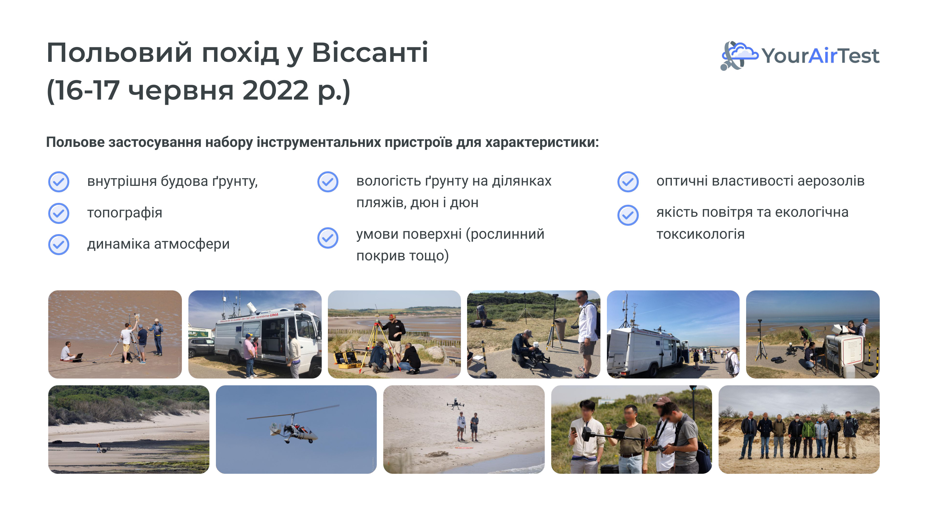
Two days, six parallel measurement domains, more than ten instruments on one site between the Cap Blanc-Nez and Cap Gris-Nez headlands. LPCA’s objective: characterising coastal vulnerability — shoreline erosion, vegetation decline, marine flooding. Our objective: validating YAT-Meteo in a complex coastal configuration. Both goals ride on the same dataset.
Why Wissant
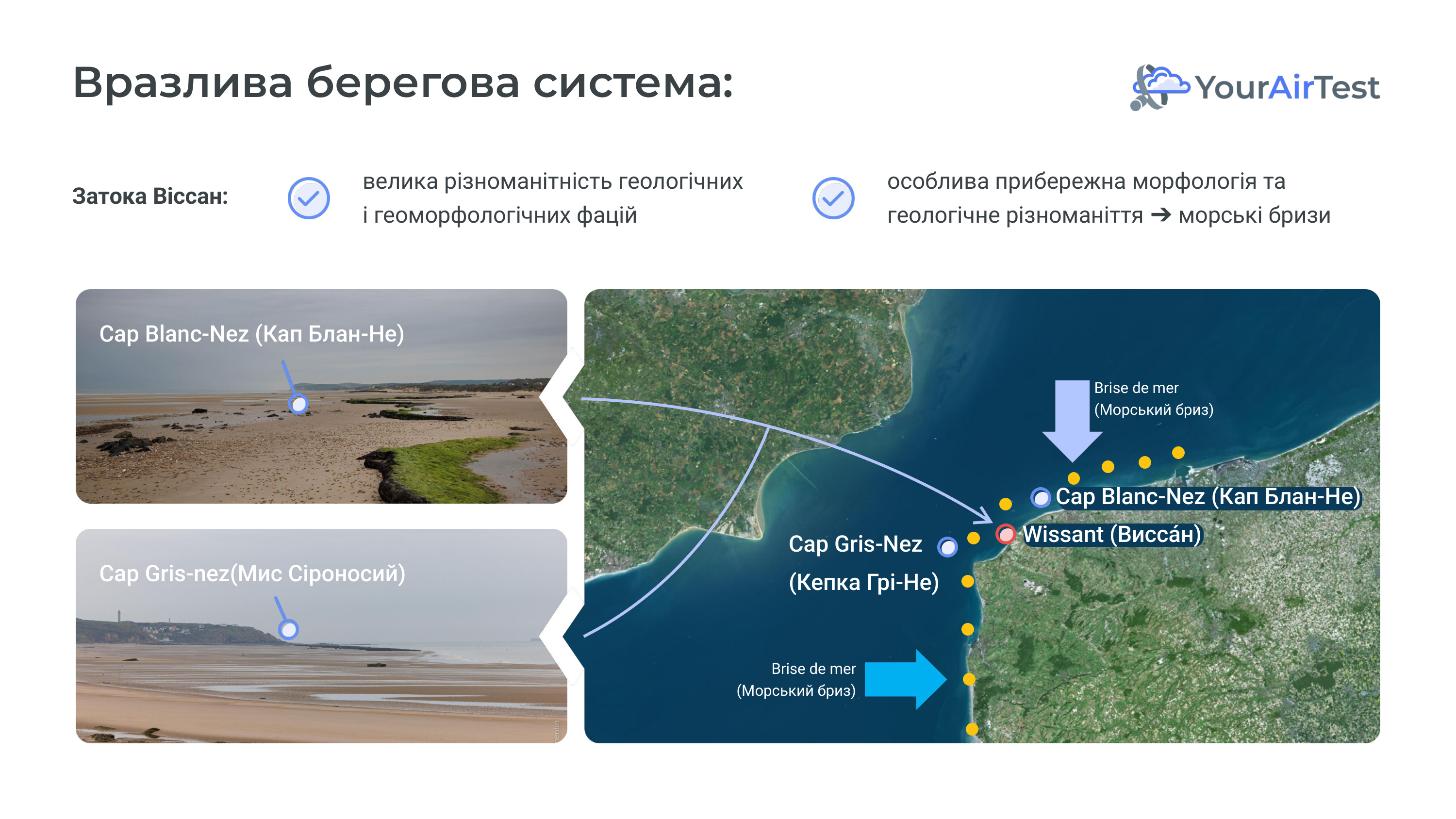
The bay combines several meteorological effects in one spot:
— Complex coastal morphology: two tall chalk headlands (Cap Blanc-Nez at 132 m, Cap Gris-Nez at 50 m) funnel sea breezes and deflect wind locally.
— Intense shipping: the Strait of Dover is one of the world’s busiest maritime routes, producing a background of SO₂ and NOₓ emissions.
— Variable geology: beaches, dunes and salt marshes — different surface roughness over short distances, affecting near-surface wind.
A configuration in which a weak meteorological model fails immediately. Ukraine’s closest analogue is the Azov and Black Sea coast, but open high-quality validation data from those areas is scarce.
Partner: LPCA / ULCO and the UMA mobile platform
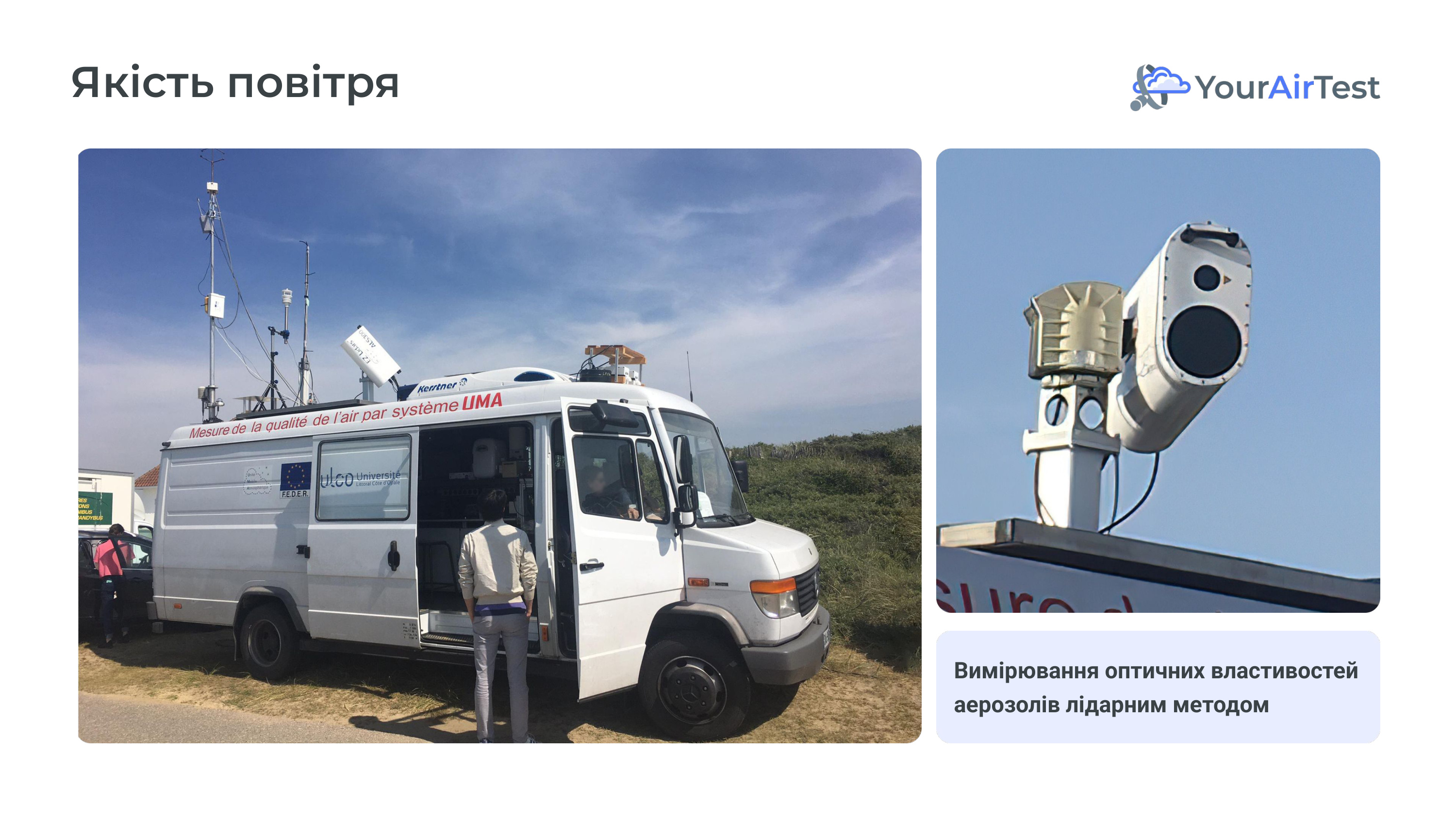
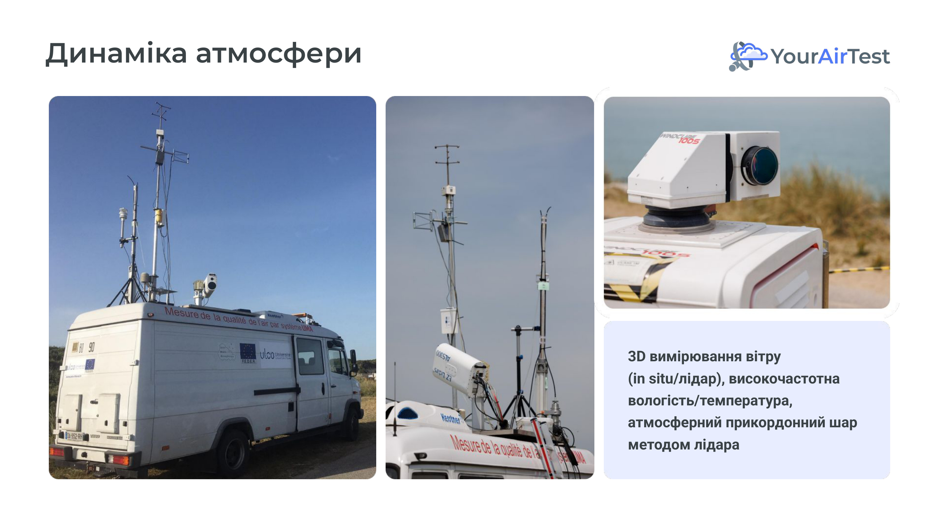
The Laboratoire de Physico-Chimie de l’Atmosphère is a research lab for atmospheric physics and chemistry at ULCO (founded 1991). The workhorse we used is UMA (Unité Mobile Atmosphérique) — a mobile laboratory in a truck: mast with meteorological sensors, Doppler lidar on top, gas and particulate analysers inside, autonomous power and climate control. A full field station that can deploy on a new site within an hour.
Six measurement domains
The campaign characterised, in parallel:
— Atmospheric dynamics: three-dimensional wind field (lidar + surface anemometer), high-frequency humidity and temperature, boundary-layer structure.
— Air quality — gas phase: NO₂, O₃, CO, CO₂ in real time.
— Air quality — aerosol phase: PM10, PM2.5, PM1 via optical counters and extractive methods; black carbon via MicroAeth.
— Aerosol optical properties: a separate ALS300 aerosol lidar for the vertical profile of optical density.
— Drone-based measurements: NO₂, SO₂ and PM at elevations the ground mast cannot reach.
— Topography and surface roughness: DGNSS surveying with reference and rover stations, drone photogrammetric 3D modelling.
Rare circumstance where a meteo model is tested not against a single variable but against a coherent dataset from the surface up to 1.5 km.
In parallel — air, aerosols, drones
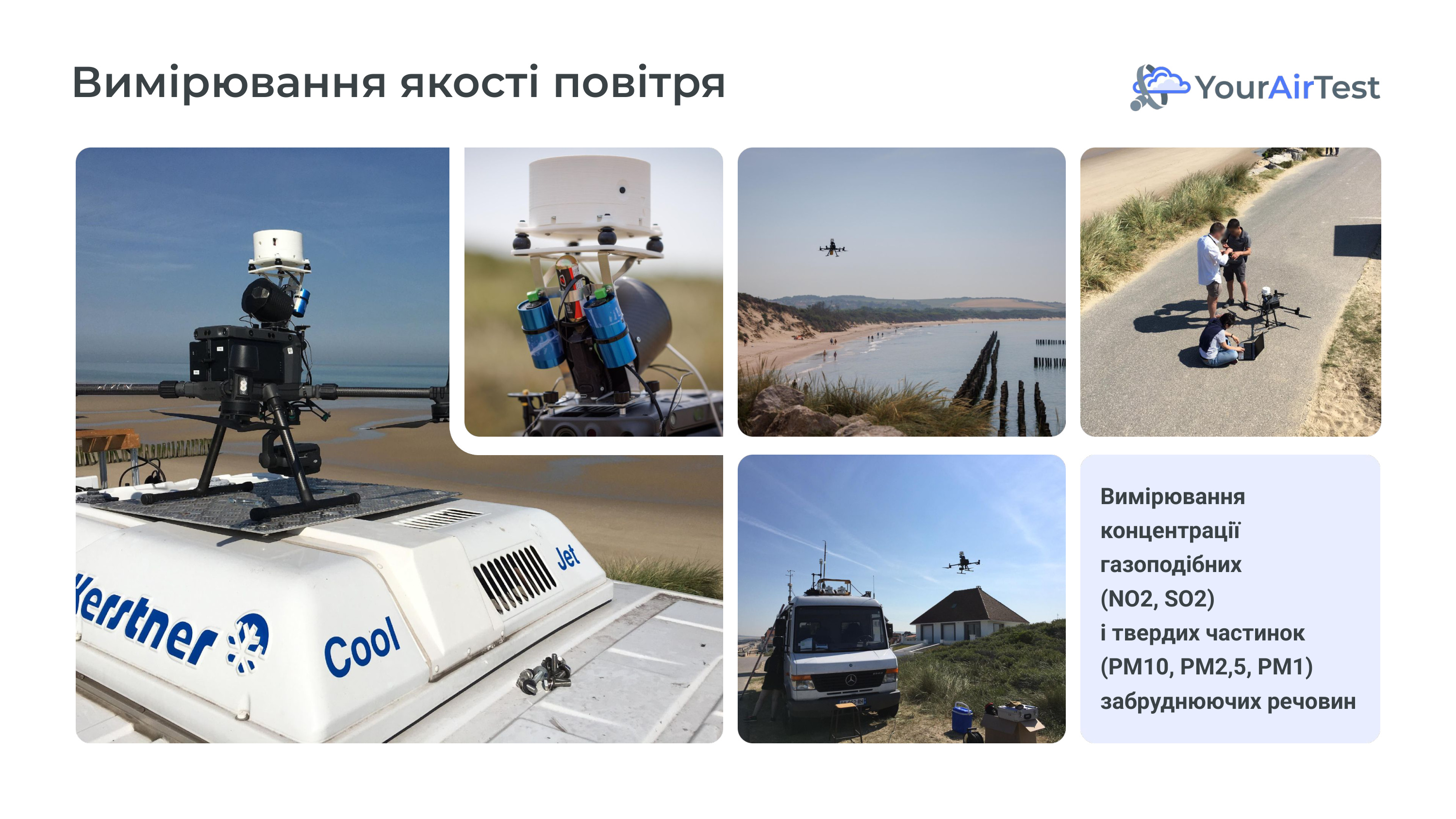
Alongside wind measurements, the UMA platform recorded gas composition (NO₂, O₃, CO, CO₂) and the aerosol fraction (PM10, PM2.5, PM1). A separate ALS300 lidar built the vertical profile of aerosol optical properties — useful for interpreting the WINDCUBE lidar signal itself.
Drones carried miniature analysers and optical counters and flew vertical profiles the mast cannot reach. That gave a second, independent validation axis: comparison of lidar profiles against direct in-situ profiles of the same air volume.
Surface roughness — DGNSS and photogrammetry
A separate team ran precise topographic surveying: differential GNSS with a reference station and rovers, plus drone photogrammetric 3D modelling of the dunes and marshes. This matters for boundary-layer modelling: surface roughness (roughness length z₀) enters the vertical wind-profile equation directly. An error of 10 cm in z₀ produces a systematic offset of tens of metres higher up in the model.
More about the model itself — see AI YAT-Meteo.
Ukrainian startup ecosystem: follow TechUkraine and AIN.ua — the two leading outlets covering Ukrainian deep tech, climate tech, and environmental startups.
Follow Ukrainian media: Ekonomichna Pravda, Mind.ua, and Hromadske regularly cover the environmental consequences of war, air pollution, and infrastructure risk in Ukraine.
What to do today
- Check the YourAirTest air map for your city.
- If this resonated — share the article.
- Subscribe to our articles on air quality in Ukraine.
References
Leosphere / Vaisala. WINDCUBE 100S — Scanning Doppler Lidar for Boundary Layer Profiling. Technical Specifications. (Manufacturer documentation used during the June 2022 Wissant campaign.)
Blackadar AK. (1957) Boundary layer wind maxima and their significance for the growth of nocturnal inversions. Bulletin of the American Meteorological Society 38(5):283–290.
Banta RM, Pichugina YL, Newsom RK. (2003) Relationship between low-level jet properties and turbulence kinetic energy in the nocturnal stable boundary layer. Journal of the Atmospheric Sciences 60(20):2549–2555.
LPCA / Université du Littoral Côte d’Opale. Focus on the SFR Campus de la Mer campaign in Wissant (June 2022). Partners: LPCA, SFR Campus de la Mer, Pôle de Recherche MTE, ULCO. LPCA