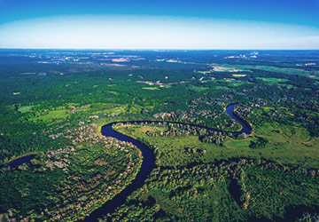
WildFiresUA is Ukraine’s first forest fire forecasting system. Most systems show where fires are burning right now. WildFiresUA shows where fires will burn in 4–24–240 hours—and where the smoke will go. Ukraine is getting a fire forecasting system based on detailed fuel maps of Ukraine—which types of vegetation burn, how quickly, and with what intensity.
is Ukraine’s first forest fire forecasting system. Most systems show where fires are currently burning. WildFiresUA shows where fires will burn in 4–24–240 hours—and where the smoke will drift. Ukraine is getting a fire forecasting system based on detailed fuel maps of the country—which types of vegetation burn, how quickly, and with what intensity. Every year, Ukraine loses thousands of hectares of forests and land to fires. The State Emergency Service, local governments, and communities react after the fact—responding to fires that are already burning. WildFiresUA was created to change this: to give rescuers and local authorities a forecasting tool that allows them to act several hours in advance.
We don’t just monitor. We model, predict, and warn.
In 2019, we started as an air quality monitoring service for citizens—sensors, maps, a mobile app. On February 24, 2022, everything changed.
Large-scale fires became a reality of war. We realized: there is no system in Ukraine that predicts where fires will break out. There is only reactive monitoring. We decided to fix this.
Three years of research, field data, and scientific partnerships with leading institutes and universities in Ukraine, and the Kyiv region has already been launched—and WildFiresUA has moved from a concept to a working system, which we are currently configuring and validating.
Nowadays, every visitor of yourairtest.com has the opportunity to see the current state of the air in his location in 100 countries around the world. In addition, air flows are visualized, which will become a forecast of air pollution in the near future.
The site has easy access to visual information, details about the project and answers to the most common questions.
WildFiresUA is a system for detecting forest fires, analyzing their development, and modeling emissions.
WildfiresUA Identification - fire detection
WildfiresUA Evolution - fire development modeling
WildfiresUA Pollution - assessment of emissions and their spread
It is important to understand that large-scale fires pose a great threat to human life and health, even in regions far from the fire zone itself, as smoke can sometimes spread for tens of kilometers or more.
In the realm of weather forecasting and atmospheric research, precision and innovation are paramount. This case study delves into the development and implementation of YAT-Meteo, a groundbreaking weather research and forecasting product.
MonAir Out - is our full-featured ground-based monitoring stations for atmospheric air with electrochemical sensors which send real-time data on humidity, temperature and pressure levels as well as on presence of O3 (ozone), NO2 (nitrogen dioxide), SO₂ (sulfur dioxide) and CO (carbon monoxide) gasses and two types of dust PM2.5; PM10.
MonAir In - is our home and office air quality sensors that send real-time data on moisture level, temperature and pressure, and AQI.
The mobile app is designed to reduce people's health impacts from poor air quality. We provide accurate data on 6 key pollutants: PM2.5 particulate matter, PM10 particulate matter, O3 (ozone), NO2 (nitrogen dioxide), SO₂ (sulfur dioxide) and CO (carbon monoxide) in the required format (U.S.AQI and EAQI ). We also added a weather forecast.
The app also has the ability to add your locations to favorites, quick to share results and available personalization in the form of four characters (male, female, astronaut and alien).
In the future, the iOS and Android app will be enhanced with an air pollution forecast and notifications of significant deterioration in advance.
We've developed a service that forecasts the potential fallout for up to 24 hours. This system provides insights into the likely path of radioactive particles carried by the wind and their concentration levels. This information allows us to assess which areas might be affected and where the radiation's impact would be most severe.
With the support of universities, we are creating trainings to teach citizens, ecologists and students about the basics of ecology and the effects of air pollution on health, as well as what to do, where to look for information and how to interpret it.
For those who want to dive deeper into air pollution modeling, we suggest exploring the Gaussian Plume Model with us.
The Gaussian Plume Model is the most common air pollution model. It is based on a fairly simple formula that describes the three-dimensional pollution concentration field produced by a point source under steady-state meteorological and emission conditions.
This model is used to predict the pathways and concentrations of pollutants in the air during transport and dispersion in the atmosphere after an emission. These models can be used for emergency preparedness as well as response and recovery operations.
 5 Universities


The goals of YourAirTest team directly correlate with the The Sustainable Development Goals (SDGs), set in 2015 by the United Nations General Assembly. Anong this 17 sustainable development goals the leading for our project are the following:

Good Health and Well-being

Clean Water and Sanitation
LIFE ON LAND

PARTNERSHIPS
for sustainable development